Flooding has become more common in the Netherlands in recent years. Therefore, southern safety regions want to be well prepared. Getting residents evacuated in a timely manner is a challenge, especially when conditions change by the hour. That is why MICD, TU Delft and Argaleo are developing an online tool to channel evacuations.
Duration
2024 – 2025Partners (TU Delft)
MICD, Faculty CEG – Department Transport & PlanningPartners (other)
Six south safety regions (Fieldlab Zuid 6): Zeeland, Midden- en West-Brabant, Brabant Zuidoost, Brabant-Noord, Zuid-Limburg and Limburg-Noord; Argaleo; Rijkswaterstaat.
Weather conditions are becoming more extreme and flood nuisance is increasing; both in frequency and as well as in magnitude. That is why authorities in the southern part of the Netherlands are joining forces: municipalities, emergency services (fire brigade, police, ambulance) and water boards are pulling together to be well prepared for future floods.
TU Delft and MICD have a lot of experience in digital models for simulations and traffic management as well as in developing strategies to vacate areas as efficiently as possible. Within this project, the researchers, together with the Safety Regions, are developing realistic digital replicas of the areas in the provinces of Zeeland, Limburg and North Brabant. With this ‘digital twin’, they demonstrate the effect of rising water: which roads would still be accessible and how to evacuate people safely? If a dike breaks or a road floods, what are alternative routes? And how can you balance the traffic so that roads do not immediately become overcrowded, causing evacuation to stall? Training in advance for realistic situations is essential. The authorities can then better assess the situations in the event of a flood and make more informed decisions.
Phasing and structure
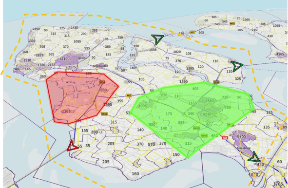
Initially, the project focuses on Zeeland, where a great deal of historical knowledge exists in the field of water management. The digital twin includes the entire infrastructure with roads, water and buildings. This will be linked to the traffic simulation model (Marple), which TU Delft and Rijkswaterstaat previously developed together. In the tool, researchers can add the effects of rising water and model this: producing different variables. During a storm, the water behaves differently from a large water inflow from inland. Traffic flows and interventions (such as evacuation or diversion) directly show the effect on the increase or decrease of potential hazard. The required evacuation time is also charted.
First, the research group develops simulations for evacuations by car. At a later stage, they will develop models for early evacuation by bus, on bicycles and on foot. Emergency services, rescue workers and other authorities will review and practice this information during training sessions. This provides valuable practical knowledge, not only on different routes and required evacuation time, but also on behaviour. In a stressful situation, people who have to leave an area do not always act as instructed by the authorities. In addition, extensive attention is also paid to the stress experienced by decision-makers: they must improvise, collaborate and make life-saving decisions at lightning speed under enormous time pressure. When trained together beforehand, they are better prepared.
Digital innovations
This data-driven approach aligns well with the security regions’ ambition to implement more digital innovations supporting their work. The eventual goal of this project is to develop a generic evacuation module that can be used anywhere in the Netherlands. In the future, the local situation will be fully customisable in a digital model. In densely populated cities, in a region with intensive logistics traffic or in a region with a lot of livestock farming, totally different challenges arise than in an area with fewer inhabitants and numerous tourists. MICD and TU Delft are therefore committed to further developing this evacuation tool in the coming years.

